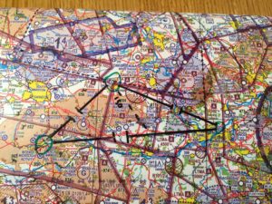
Now I have the basic skills to fly an aeroplane it’s time to put that to use and start going places! This lesson is to navigate from the airfield to Malborough, then to Grove and back to the airfield. We will pass through Beson MATZ so will need approval from them. We will also request a basic service from them so lots of new radio work for me!
We spent nearly 2 hours plotting the route, going over the CRP1, planning the leg times and speeds from the F214 wind chart for today.

Draw circles on the chart around the starting point (reporting points) and destination(s)
Draw a straight line between the points (not into the circles though)
Check the min safe altitude for the squares and a knuckle width either side for min safe altitude + 1000. This should be ground clearance and not danger areas for example
True track with protractor
True heading taking wind into account from F214 using crp1
Magnetic heading from variance (1 degree around EGLM but dotted blue line on chart)
True Air speed from altitude and air temp on crp1
Ground speed from true air speed and wind factor
Time from speed and distance, setting “60” on crp1 to ground speed
Checkpoint(s), distance and time
Possible comms
Calculate fuel useage at 10 per hour
Once at first reporting point (Whisky / November / Sierra), turn, note time and calculate etas
Turn
Times
Think (gross errors, eg motorway should be on north!)
Talk
Enroute – FREDA
Few mins before checkpoint start looking for it
At checkpoint HAT
Heading
Altitude
Time Update etas
